Image processing concerns all systems based on visual data such as satellite images, aerial photos, medical imagery, surveillance videos or photos of all kinds. Faced with growing demand in a context where sensors are reaching the limits of their performance, image processing plays a key role in geo-spatial intelligence and risk-management scenarios.
As a center of excellence in the field of image processing, CS GROUP deals with the entire process, from modeling sensors to designing integrated systems. Our ability to optimize image-based information and to extract useful data from it brings significant added value to respond to the challenges faced by our civilian and military clients.

A leading European specialist in the field of geophysical data, satellite images and drone footage, CS GROUP integrates, within the same system, information provided by space observation, telecommunications, collection and location technology, enriched by on-site surveys and meteorological data.
CS GROUP thus provides complete image processing chains that can be either completely automatic or a suite of relevant tools for the production of image-based information. This “system-oriented” concept has many areas of application including command and surveillance centers, automatic object recognition systems, environmental data analysis centers (agriculture, land registries, weather, seas and rivers) and autonomous vehicles (drones, robots, assisted driving technology).
CS GROUP responds effectively to all of its clients’ requirements, from carrying out studies to define future instruments to developing operational tools, always taking into account the challenges of interoperability and operational performance.
CS GROUP is developing Orfeo ToolBox, a library dedicated to the processing of remote sensing images, for the CNES.
Orfeo ToolBox (OTB) is a freeware solution (distributed under license from CeCILL), defined and set up by the CNES as part of the methodology of the ORFEO project, whose aim is to prepare future Pléiades and Cosmo-Skymed data for use. The library is designed to capitalize on the results of studies and research work carried out in different methodological groups, and offers its users algorithms and cutting-edge international research methods. Moreover, the fact that the CNES and the partners of the ORFEO program approve these algorithms guarantees their accuracy and quality.
CS GROUP has developed GeoStorm, a Geo-Information platform designed to store, process and distribute all kinds of geolocated and geolocateable data.
GeoStorm makes it possible to work with data from thousand of sensors and to visualize the changes taking place in a given system in a centralized way. The platform is very efficient in implementing real-time infrastructure management systems, allowing complete control of the process from supervising sensors to processing the data obtained:
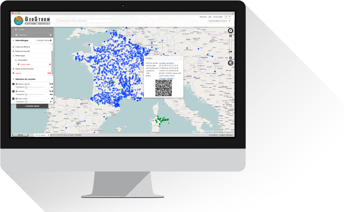
Uses of GeoStorm including mapping/visualizing railroad infrastructure, managing sets of sensors and drones for the surveillance of urban environments, and setting up Terrestrial image processing chains for GeoStorm platforms such as the ESA platform.
Ten firms and organizations trust GeoStorm to respond to a variety of challenges:

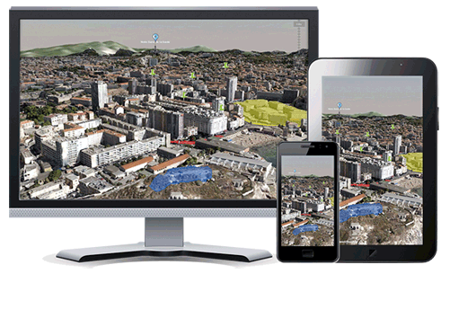
As a complement integrated into GeoStorm or other systems, CS GROUP offers VirtualGeo, a real-time 3D cartographic module that displays and creates geographical environments on the scale of the planet or the interior of a building. VirtualGeo is widely used in the defense, aeronautics, space and energy sectors.
VirtualGeo offers a complete software suite using the latest cutting edge technology to build a bespoke geospatial solution or a sub-set adapted to your existing system.